
Saturday September 5, 2026
www.thenewsdesk.ng
The United Nations General Assembly has endorsed a new world map designed to give a more accurate representation of Africa’s actual size, in a move aimed at correcting distortions associated with the widely used Mercator projection.
The resolution, known as the “Correct the Map” initiative, was sponsored by Togo and supported by members of the African Union. It secured the backing of 164 countries, including France and the United Kingdom, while the United States voted against it. Six countries abstained.
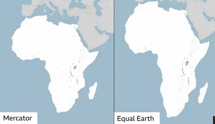
The decision targets the Mercator projection, a map created in 1569 by Flemish cartographer Gerardus Mercator and widely used for centuries, despite its distortion of the relative sizes of countries and continents.
One of the most notable distortions is the apparent size of Africa compared with Greenland. Although Africa is about 14 times larger than Greenland, the Mercator projection makes the two land masses appear comparatively similar in size.
Critics of the projection argue that the distortion can influence perceptions of the importance, scale and development potential of countries located around the equator, particularly in Africa.
The Mercator projection was originally developed to assist European explorers with navigation. Its distortions stem from the difficulty of transferring the curved surface of a globe onto a flat map.
As a result, world maps must make compromises, with different projections prioritising factors such as shape, distance, direction or area.
Under the Mercator system, areas close to the equator appear smaller than their actual size, while territories nearer the poles are exaggerated.
Efforts to address the problem led cartographers in 2018 to develop the Equal Earth projection, an equal-area map intended to provide a more accurate comparison of the size of continents.
The African Union’s 54 member states adopted the Equal Earth projection in February, saying it “more accurately represents the sizes of all continents, particularly Africa”.
Ahead of Friday’s UN vote, Togo’s Foreign Minister, Robert Dussey, told Reuters: “A fair world begins with a fair map.”
Speaking earlier at a UN briefing, Dussey said: “A map is never neutral. It shapes perceptions, influences how the place of peoples and continents in the world is understood.”
Although the General Assembly resolution is not legally binding, it is expected to encourage institutions and organisations around the world to reconsider the maps they use and adopt representations that more accurately reflect the relative sizes of continents.
The development marks a symbolic push by African countries to challenge long-standing geographical representations and promote a map that better reflects the continent’s physical scale.
(Platinum POST)
